May 7th, 2019 at 8:01 AM
(This post was last modified: May 7th, 2019 at 8:19 AM by Darvince.
Edit Reason: math
)
Update 2
In this update I will show the public transit situation in Chinauk. There's not very much of it but actually compared to real-world cities there is an impressive amount of public transit usage!
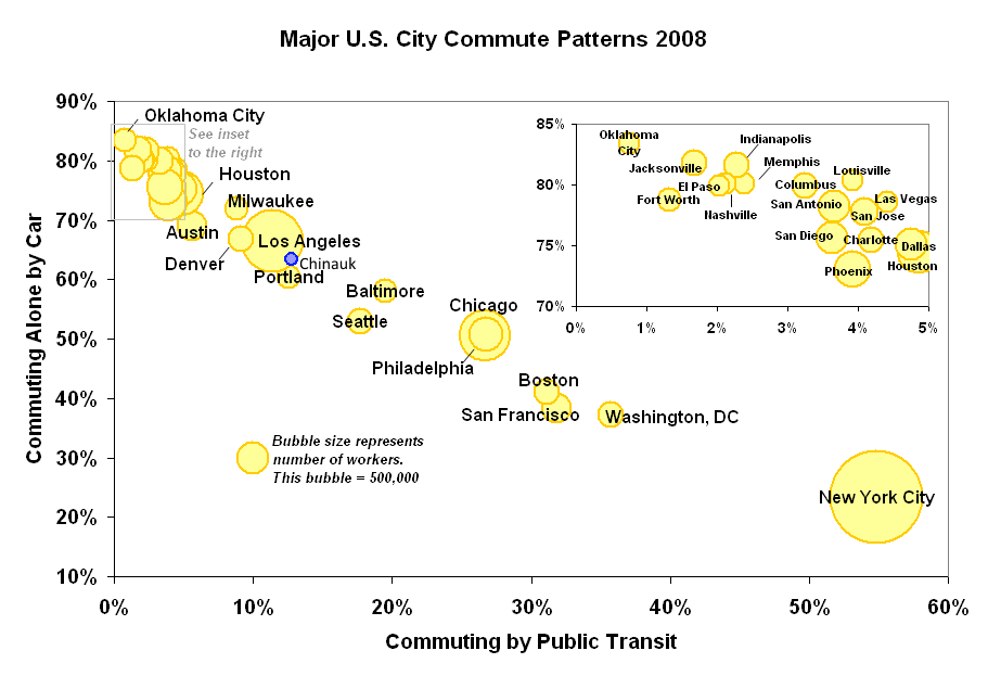
I saw a chart about a week ago that plotted how many trips people take by public transport and how many they take by car, in American cities. I got curious where my city Chinauk would place on this chart since I had placed many bus stops throughout the city to encourage people to take the bus. That will be the focus of this update. Here's an area that is served quite well by buses, to give you an idea of how well Chinauk is serviced by buses:
![[Image: 74x7th6.png]](https://i.imgur.com/74x7th6.png)
It seems to me that for some reason people are willing to walk much more than twice as far to get to work, than to get to a bus stop.
Here is the city's overview of used bus lines:
![[Image: LsK5kdx.png?1]](https://i.imgur.com/LsK5kdx.png?1)
Despite appearances there are lots of bus stops inside the suburban neighborhoods, but they don't have enough users to show up until they are on the main roads most of the time.
Here is the chart I saw: https://upload.wikimedia.org/wikipedia/c...ns2006.png
For Chinauk, it has about the following, found by pixel counting on the traffic volume chart for each type of travel, and then rounding to the nearest 100:
Car trips - 33,800
Walking - 12,600
Bus trips - 6,700
Light rail - 100
Adding those together we get 33,800 for car trips, 6,800 for public transport, and 53,200 total trips, placing it here on the chart:

And this is what it looks like in-game. You can't even see the light rail usage yet!
![[Image: WaTJzrK.png?1]](https://i.imgur.com/WaTJzrK.png?1)
Here is my baby light rail line. Its users increased from just ten (!) to ninety-four after I added in some new mid-density zoning around it. As you can tell, the area is still very young as there are plenty of services around but all the zoning is for poor people and their businesses. The taller commercial building that I remember being everywhere in CSG's cities had just finished building right before I took this screenshot.
![[Image: Dr8K7Ol.png]](https://i.imgur.com/Dr8K7Ol.png)
That's all for today!
In this update I will show the public transit situation in Chinauk. There's not very much of it but actually compared to real-world cities there is an impressive amount of public transit usage!
I saw a chart about a week ago that plotted how many trips people take by public transport and how many they take by car, in American cities. I got curious where my city Chinauk would place on this chart since I had placed many bus stops throughout the city to encourage people to take the bus. That will be the focus of this update. Here's an area that is served quite well by buses, to give you an idea of how well Chinauk is serviced by buses:
![[Image: 74x7th6.png]](https://i.imgur.com/74x7th6.png)
It seems to me that for some reason people are willing to walk much more than twice as far to get to work, than to get to a bus stop.
Here is the city's overview of used bus lines:
![[Image: LsK5kdx.png?1]](https://i.imgur.com/LsK5kdx.png?1)
Despite appearances there are lots of bus stops inside the suburban neighborhoods, but they don't have enough users to show up until they are on the main roads most of the time.
Here is the chart I saw: https://upload.wikimedia.org/wikipedia/c...ns2006.png
For Chinauk, it has about the following, found by pixel counting on the traffic volume chart for each type of travel, and then rounding to the nearest 100:
Car trips - 33,800
Walking - 12,600
Bus trips - 6,700
Light rail - 100
Adding those together we get 33,800 for car trips, 6,800 for public transport, and 53,200 total trips, placing it here on the chart:
And this is what it looks like in-game. You can't even see the light rail usage yet!
![[Image: WaTJzrK.png?1]](https://i.imgur.com/WaTJzrK.png?1)
Here is my baby light rail line. Its users increased from just ten (!) to ninety-four after I added in some new mid-density zoning around it. As you can tell, the area is still very young as there are plenty of services around but all the zoning is for poor people and their businesses. The taller commercial building that I remember being everywhere in CSG's cities had just finished building right before I took this screenshot.
![[Image: Dr8K7Ol.png]](https://i.imgur.com/Dr8K7Ol.png)
That's all for today!


